| canoe_trail_h1.all_map.pdf |
Paiwalla Canoe Trail
Directions
From the boat ramp paddle up river for 3.5 km until a large dead Red Gum is sighted on the eastern side of the
main river channel.
From the dead Red Gum, navigate towards the old farm house on the eastern bank entering the Paiwalla North Wetland.
For your safety we refer you to http://www.southaustraliantrails.com/activities/canoeing/
and suggest you fill out a float plan form and give to someone to monitor for you.
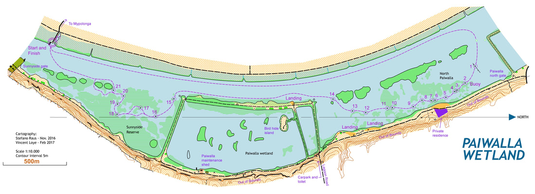
Directions
From the boat ramp paddle up river for 3.5 km until a large dead Red Gum is sighted on the eastern side of the
main river channel.
From the dead Red Gum, navigate towards the old farm house on the eastern bank entering the Paiwalla North Wetland.
- Marker 1 – is attached to an old fence post about 100 m from the main river channel.
- Marker 2 – A red buoy is attached. This marks a narrow channel entrance. Paddle downstream, adjacent to the river bank.
- Markers 3 to 12 - pass through a series of small lagoons and clumps of reeds.
- Marker 14 –head back towards the main river channel using a pump shed located on an embankment as a directional guide. An unmarked section of the trail follows the river downstream for approximately 1 km passing a large sluice gate which controls water to the main wetland.
- Marker 15 - marks the entrance to Sunnyside Reserve.
- Markers 15 to 20 – route meanders downstream through a series of lagoons. (Please note any park rules and restrictions)
- Marker 21 – Re-enter the main river channel – return across river to the boat ramp.
For your safety we refer you to http://www.southaustraliantrails.com/activities/canoeing/
and suggest you fill out a float plan form and give to someone to monitor for you.
